Spatial mismatch
Survey coordinates, mapped routes and execution records can disagree.
Built for Project Implementation Agencies
Connect field work, network records and operational decisions across your BharatNet project.
The challenge
When survey, GIS, execution and operations work from separate copies, every handover becomes a reconciliation exercise.
Survey coordinates, mapped routes and execution records can disagree.
Photos, videos and supporting files become difficult to match to the right location or revision.
KML/KMZ conversions, exports and imports create repeated checking and manual rework.
Field changes can reach reporting teams and SNOC at different times.
An everyday O&M scenario
A repair can change cable length, slack distribution or splice position. Closing the ticket alone does not bring the network record up to date.
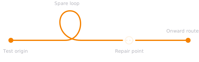
OTDR measures distance along the fibre. GIS places that distance on the ground.
Service is restored.The field team uses spare loop cable to repair a cut.
The record can fall behind.Changed slack, splice position or cable length remains unrecorded.
The next fault is harder to locate.A distance reading interpreted against old records can point to the wrong ground location.
Using a loop does not necessarily change total fibre length. The risk depends on what changed and whether the spatial and optical records were updated.
The Xentric platform
Manage the network, survey the field, deliver construction and coordinate operations within one platform.
01 / GIS Server Solution
Bring spatial data management, map tools and SNOC visibility together to support network monitoring and fault rectification.
A GIS server solution with map tools, spatial data management and live monitoring for the SNOC environment.
Work with network geography and map tools in the project context.
Give operations geographic context for investigation and field response.
Keep spatial management within the project workflow instead of relying on repeated file handovers.
02 / Survey Solution
Monitor POP and route-kilometre surveys with geo-tagged field capture and supporting evidence.
Monitor field surveys and collect geo-tagged supporting proofs. Preserve the initial POP and handover/takeover (HOTO) records for later maintenance use.
Extend the field record into a reviewed, approved source for GIS and operations.
03 / Execution Solution
Connect construction activity, geographic context and supporting records so progress reviews can reach the work behind the numbers.
Review construction activity by package, block and job, with geographic visibility.
Inspect geo-tagged photos, videos and work records behind reported completion.
Retain execution knowledge for handover, fault investigation and maintenance.
04 / WFMS Solution
Bring field teams, ITSM ticketing, FRT and patrol activity into the same operational review as SLA and restoration performance.
Field teams, manpower and vendor visibility.
FRT, patrol activity, field tracking and ticket response.
SLA, mean time to repair (MTTR) and root-cause analytics.
Personnel, assets, vehicles and material records.
Continuity across the lifecycle
Put the investment in survey, HOTO and execution records to work throughout the 10-year maintenance period, with field changes keeping the baseline current.
The maintenance horizon
Initial POP condition, route survey and geo-tagged proofs.
Work records, photographs, videos and supporting files.
Reference the original evidence and record subsequent field changes.
The original survey and HOTO baseline stays useful when maintenance changes are recorded against it.
PIA · IE · BSNL
Give authorised stakeholders direct access to relevant project information through their logins, reducing repeated report preparation and circulation.
Review progress, deployment, vendors and operational performance.
View relevant project information and supporting evidence through an authorised login.
Access relevant records directly for visibility and review.
Operational records are accessed through authorised accounts. This public overview does not grant access to project data.
Everything in one platform
Support the four core solutions with the workforce, commercial and resource-management capabilities a PIA needs.
Built for BharatNet · Used in the field
Developed from the ground up for this project and implemented across three packages with actual project data.
Actual project data and field use.
GIS capability deployed for the SNOC environment with live monitoring.
Survey, execution and operational workflows shaped around BharatNet requirements.
Deployment scope is specific to each package. The planned survey approval-to-GIS workflow is identified separately in this overview.
Your evaluation
Use a focused walkthrough to assess how the platform fits your package, teams and existing SNOC environment.
Follow a survey or execution record through its location, evidence and use in maintenance.
Review team deployment, a ticket lifecycle and the service-performance measures behind it.
Agree stakeholder access, existing data, SNOC interfaces and the rollout sequence.
The next conversation
Arrange a 30-minute walkthrough with your project, GIS/SNOC and operations leads. Start with the workflow that matters most to your PIA.
Include your package and priority solution in the email so the session can focus on your requirements.